NEODAAS & FSF Training Course - November 2021
Welcome!
Welcome to the NEODAAS & FSF training course 2021.This training course has two components, an online self-guided introductory phase and the main taught phase which will be held virtually between the 8th - 11th November.
Objectives
By the end of this course participants will:
- Be aware of the range of sources and applications of EO data and understand the factors to consider when choosing EO data for their work.
- Understand the importance of atmospheric correction and be able to run a relevant atmospheric correction for their work.
- Understand how and why to collect in situ field spectroscopy data and how this can be used to classify a multispectral image.
- Have an awareness of how AI can be used to extract information from EO data.
- Have a workflow plan to show how they could use EO data for their work.
Essential tasks prior to the practical sessions
Please complete the following prior to the taught phase of the course. If you have any problems with setting up your computer please come along to the pre-course setup sessions and we can help.Computer set up for practical sessions
If you do not already have a GitHub account, please sign up here. This login will be used to give you access to Jupyter notebooks for the course on our computing cluster (MAGEO). Please send your GitHub user ID to us at neodaas-ai@pml.ac.uk by the 1st November.For most of the practical sessions we will assume people are using a Windows machine which they have an admin account for. If this isn't the case then it might take a bit longer to set up, but there are some pre-course setup sessions where we will be available to help you out.
Software Installation
- General set up instructions (pdf)
- Installing Anaconda (video)
- Installing Python packages using Anaconda (video)
- Installing SNAP (video)
- Installing ACOLITE (video)
- Data for Hyperspectral Practical (zip 547 MB), macOS users having problems installing APL via Docker can also download APL output data (zip 910 MB)
- Sentinel 2 Scene for atmospheric correction practical (zip 659 MB)
Introductory pre-course phase (25th October - 8th November)
If you are new to EO or need background information on specific topics, please explore the material below in preparation for the course. 1. Who are we?- Introduction to NEODAAS, FSF and NAEO - a talk from NCEO Community needs townhall 2021 (video)
- NASA Earth Science Applied Science - Fundamentals of Remote Sensing (link) If you are new to EO, this course gives a great background to remote sensing, including concepts like spatial and spectral resolution and data processing levels which we will use in the course.
- Short training video to revise key remote sensing concepts (video)
- Short training video to introduce the remote sensing data processing levels and latency (video)
- Sentinel 1, 2 & 3: summary of technical capabilities - video
- The Copernicus Marine Landscape discussion - video - Hayley Evers-King joins Lauren Biermann for an informal discussion to help simplify the Copernicus Marine Landscape, talking through the different missions, mechanisms and agencies. This video has a marine focus but an understanding of the Copernicus landscape is useful for all researchers when it comes to finding out who collects the data you want, where to find it, and who to go to for help.
- Continuing Landsat’s 40-year Legacy - video - This video talks about the Landsat series and specifically Landsat 8. The most recent satellite in the series, Landsat 9, was launched on 27/09/2021. Landsat 9 largely replicates Landsat 8 and means observations are now available every 8 days using the two satellites.
- Progress In Field Spectroscopy (pdf)
- Introduction to NEODAAS AI Services (video)
- When Deep Learning meets satellite imagery (video) This video highlights some of the things to consider when using satellite imagery for ML/AI.
- Machine Learning for Remote Sensing Data Analysis (video)
- How do we track and trace carbon from space? The Royal Society Summer Science 2021. Paul Palmer, Mat Disney and Gemma Kulk explore how satellites are used at the cutting edge of climate science (youtube)
- TEDx - Painting by Numbers - Hayley Evers-King. An introduction to Ocean Colour (youtube)
- TEDx - Taking the pulse of our planet from space - Pierre-Philippe Mathieu (youtube)
- Earth Observation from Space: the Optical View (homepage) Online training course from ESA with videos introducing a range of applications of satellite EO data.
Taught phase 8th - 11th November
The course timetable for the taught phase of the course can be found (here).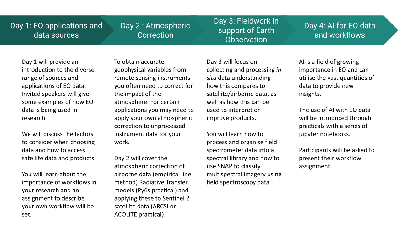
Day 1 - Introduction to EO Data
- Katie Awty-Carroll: Machine learning for environmental intelligence with EO data (pdf)
- Gemma Kulk: Using ocean colour remote sensing observations to study marine and aquatic systems (pdf)
- Tommaso Jucker: Seeing forests in 3D using remote sensing (pdf)
- What to consider when choosing data (pdf)
- Practical instructions (pdf)
- How to access sources of existing satellite data and product (pdf)
Day 2 - Atmospheric Correction
Introduction- Introduction to atmospheric correction (pdf)
- Airborne hyperspectral processing practical instructions(pdf)
- Data for Hyperspectral Practical (zip 547 MB), macOS users having problems installing APL via Docker can also download APL output data (zip 910 MB)
- Py6S practical instructions (Github)
- Data for Sentinel 2 practical (you may have already downloaded this in the introductory phase) (zip 659 MB)
- Sentinel 2 Practical instructions (pdf)
- Processed S2 data with fixed AOT (if you have problems running ARCSI; tif)
Day 3 - Fieldwork in support of Earth Observation
- Download data and practical instructions (zip 627 MB, practical instructions only, pdf)